Tracking Severe Weather: Cherry County Thunderstorm Warnings and Nebraska’s Shifting Climate Trends
Nebraska’s expansive landscapes—from the rolling Sandhills to the western high plains—make it a frontline witness to some of the most dynamic atmospheric dynamics in the United States. Among these regions, Cherry County, the largest county in the state, frequently finds itself at the crossroads of volatile weather systems.
Understanding what triggers a severe thunderstorm warning in Cherry County requires looking closely at local geography, real-time alerting systems, and the broader, evolving weather trends affecting the Cornhusker State.
Understanding Severe Thunderstorm Warnings in Cherry County
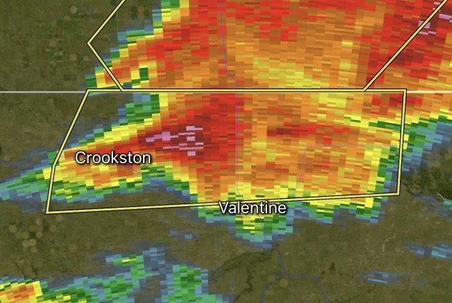
When the National Weather Service (NWS) issues a Severe Thunderstorm Warning for Cherry County, it means radar or ground spotters have indicated imminent or ongoing dangerous weather. Unlike a watch (which suggests conditions are favorable for storms to form), a warning means action is required immediately.
What Constitutes a Severe Storm in Nebraska?
A storm is officially classified as severe by the NWS when it produces one or both of the following conditions:
Winds of 58 mph (50 knots) or higher
Hail measuring 1 inch in diameter or larger (roughly the size of a quarter)
Given Cherry County’s massive geographic footprint, storms can develop rapidly over open terrain, catching travelers along U.S. Routes 20 and 83 off guard. High winds across the Sandhills can also trigger localized blowing dust or sudden, treacherous driving conditions.
Recent Weather Trends Across Nebraska
Severe weather seasons in Nebraska have experienced noticeable shifts. Observers and meteorologists point to several defining trends shaping modern Nebraska weather:
1. Increased Frequency of High-Wind Events (Derechos and Bow Echoes)
While traditional tornado threats remain a staple of spring and early summer, recent years have highlighted an uptick in destructive straight-line wind events. Systems rolling out of the high plains frequently organize into intense squall lines, bringing prolonged bouts of hurricane-force wind gusts capable of flattening crops, downing power lines, and damaging structural property.
2. Amplified Volatility and Rapid Intensification
Shifting atmospheric clashing—driven by warm, moisture-rich air lifting from the Gulf meeting dry lines descending from the Rockies—has accelerated how fast storms form. A clear morning in western Nebraska can transform into a severe supercell environment by mid-afternoon, reducing lead times for emergency alerts.
3. Extended and Unpredictable Storm Windows
Historically, peak severe weather adhered strictly to a mid-spring through early-summer timeline (April to June). However, modern patterns show volatile setups expanding deeper into the summer months alongside heightened risks for nocturnal (nighttime) severe weather systems. Nighttime storms present a unique danger because residents are often asleep and less likely to hear immediate warnings.
Essential Safety Protocols During a Warning
When a severe thunderstorm warning flashes across your devices for Cherry County, taking prompt action is critical:
Seek Shelter Indoors: Move immediately to a sturdy building. Avoid mobile homes, which are highly vulnerable to straight-line winds.
Stay Away from Windows: Flying debris and shattered glass are major hazards during high-wind events and large hail outbreaks.
Secure Outdoor Items: If you receive advanced notice, bring in patio furniture, livestock shades, or loose equipment that could become airborne.
Keep Multiple Alert Sources Active: Relying on a single siren is risky in sparsely populated rural areas. Keep a NOAA Weather Radio with a fresh battery backup alongside smartphone emergency alerts enabled.
Staying Ahead of the Storm
As weather patterns across the Great Plains continue to evolve, staying informed is your best defense. Whether you are ranching in the Sandhills or traveling through Valentine, keeping a close eye on real-time radar updates ensures you stay steps ahead of Nebraska’s unpredictable skies.
Affiliate Disclosure: As an Amazon Associate, Radar Watch HQ earns from qualifying purchases.
Radar Watch HQ Top 5 Essential Emergency Preparedness Picks
Whether you’re preparing for severe thunderstorms, flash flooding, hurricanes, wildfires, or extended power outages, these five emergency essentials can help keep your household safer when severe weather strikes.
A portable power station provides reliable backup electricity during outages, allowing you to power phones, medical devices, laptops, lights, small appliances, and communication equipment without fuel.
Best for:
- Extended power outages
- Severe thunderstorms
- Hurricanes
- Winter storms
- Wildfires
2. Flood Protection Barriers & Sandless Flood Bags
Flood barriers help divert or absorb water before it enters garages, doorways, and low-lying areas. They deploy quickly and can help reduce property damage during flash flooding.
Best for:
- Flash Flood Warnings
- Heavy rainfall
- River flooding
- Coastal flooding
3. Rechargeable LED Flashlights
Bright, dependable flashlights are essential when the power goes out. Rechargeable or solar-powered models provide long-lasting illumination for navigating safely indoors and outdoors.
Best for:
- Overnight power outages
- Emergency evacuations
- Storm damage inspections
Keep phones, tablets, weather radios, and USB-powered devices charged when the electrical grid is unavailable. A solar power bank offers an additional charging option during prolonged emergencies.
Best for:
- Communication during outages
- Emergency weather alerts
- Travel and evacuation
A NOAA Weather Radio delivers official weather alerts directly from the National Weather Service, even when cellular networks or internet service are unavailable. It remains one of the most dependable ways to receive life-saving warnings.
Best for:
- Tornado warnings
- Severe thunderstorm warnings
- Flash flood warnings
- Hurricane alerts
- Winter storm emergencies
Why Radar Watch HQ Recommends These Essentials
At Radar Watch HQ, preparedness is just as important as staying informed. These five emergency essentials can help you stay connected, protect your property, and safely navigate severe weather events. Having supplies ready before storms arrive allows you to respond quickly when warnings are issued and conditions begin to deteriorate.