When the Sky Turns: Understanding Severe Thunderstorm Warnings in Walton County, FL, and the Gulf Coast Moisture Engine
If you live in or are visiting Walton County, Florida—from the sugar-white sands of South Walton and Rosemary Beach up through DeFuniak Springs—watching a towering wall of clouds roll in off the water is a familiar routine. However, when the National Weather Service (NWS) issues a Severe Thunderstorm Warning for Walton County, Florida, it signals that the atmosphere has crossed the line from a routine afternoon shower into a potentially hazardous event.
Understanding why these intense storms happen comes down to a powerful geographic neighbor: the Gulf of Mexico. Let’s break down what a severe warning means for Walton County and how Gulf Coast moisture continuously dictates Florida’s volatile weather trends.
Anatomy of a Severe Thunderstorm Warning in Walton County
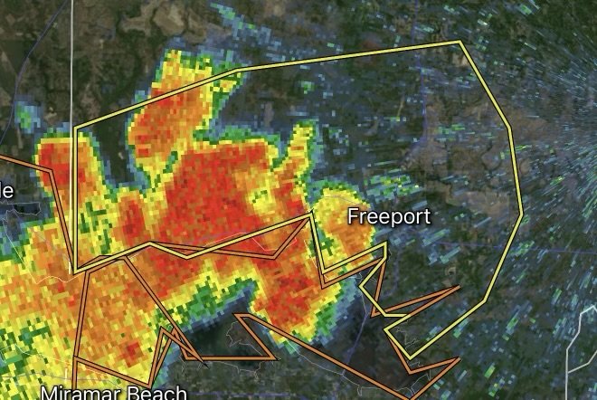
When a severe thunderstorm warning pops up on your phone or local news, it means radar has detected or a spotter has reported a storm packing winds of 58 mph or higher, and/or hail 1 inch in diameter or larger.
For Walton County, these warnings often materialize swiftly during the spring and summer months, driven by colliding air masses and high humidity.
Damaging Winds: The primary threat in Northwest Florida storms. Straight-line winds can knock down massive pine trees, snap power lines, and cause structural damage to homes and property.
Torrential Downpours & Flash Flooding: Low-lying areas and poor drainage spots in Walton County can see several inches of rain in a matter of hours, heavily impacting routes like US-331 and I-10.
Frequent Cloud-to-Ground Lightning: Florida’s crown as the lightning capital of the country means every warning carries a severe risk of dangerous electrical activity.
The Gulf Coast Connection: Fueling Florida’s Weather Engine
Why is Walton County such a frequent target for intense storm activity? The answer lies directly to its south. The Gulf of Mexico acts as a colossal thermodynamic engine that shapes local weather trends in several distinct ways:
1. An Endless Supply of Warm Moisture
The Gulf’s warm surface temperatures pump immense amounts of moisture into the lower atmosphere. High dew points (often in the mid-to-upper 70s) mean the air is saturated with latent heat and water vapor. When this humid air is heated by the blazing Florida sun, it rises rapidly, creating the towering cumulonimbus clouds characteristic of severe storms.
2. Sea Breeze Collisions
Walton County sits in a prime geographical location to experience sea breeze interactions. During the day, land heats up faster than the Gulf waters, creating an onshore breeze. When this cooler, moisture-laden maritime air pushes inland and collides with stationary boundaries or opposing breezes coming from the Atlantic side of the state, it acts like a physical wedge. The air has nowhere to go but up, forcing rapid thunderstorm development right over the Florida Panhandle.
3. Amplifying Frontal Boundaries
When cold fronts or upper-level disturbances push south out of the Deep South and encounter the rich, humid air sitting over the Gulf Coast, they trigger explosive atmospheric instability. The contrast between the drier, cooler incoming air and the sticky, warm Gulf moisture creates a volatile “spark,” frequently resulting in organized lines of severe storms capable of sweeping across Walton County overnight.
Safety Checklist: How to Protect Yourself During a Storm
When a Severe Thunderstorm Warning is active in Walton County, taking immediate action can prevent injury or property damage:
Seek Shelter Indoors: Move to a sturdy building immediately. Mobile homes and open outdoor beach pavilions are unsafe during high winds.
Stay Away from Windows: Flying debris and shattered glass are major hazards during straight-line wind events.
Never Drive Through Flooded Roads: Turn around, don’t drown. Just a few inches of fast-moving water can sweep a vehicle away.
Unplug Sensitive Electronics: Protect your appliances from power surges caused by frequent cloud-to-ground lightning strikes.
Tracking the Trends: What to Expect Moving Forward
As long as the Gulf of Mexico continues to provide warm waters and high humidity, Walton County will remain on the front lines of dynamic Florida weather. Meteorology models show that shifting steering winds and subtle coastal waves will continue to spark rapid storm cycles, particularly during peak afternoon heating hours.
By keeping a close eye on local radar, heeding official warnings from the National Weather Service, and respecting the raw power of Gulf Coast moisture, residents and visitors can stay safe no matter how quickly the Florida skies change.
Affiliate Disclosure: As an Amazon Associate, Radar Watch HQ earns from qualifying purchases.
Radar Watch HQ Top 5 Essential Emergency Preparedness Picks
Whether you’re preparing for severe thunderstorms, flash flooding, hurricanes, wildfires, or extended power outages, these five emergency essentials can help keep your household safer when severe weather strikes.
A portable power station provides reliable backup electricity during outages, allowing you to power phones, medical devices, laptops, lights, small appliances, and communication equipment without fuel.
Best for:
- Extended power outages
- Severe thunderstorms
- Hurricanes
- Winter storms
- Wildfires
2. Flood Protection Barriers & Sandless Flood Bags
Flood barriers help divert or absorb water before it enters garages, doorways, and low-lying areas. They deploy quickly and can help reduce property damage during flash flooding.
Best for:
- Flash Flood Warnings
- Heavy rainfall
- River flooding
- Coastal flooding
3. Rechargeable LED Flashlights
Bright, dependable flashlights are essential when the power goes out. Rechargeable or solar-powered models provide long-lasting illumination for navigating safely indoors and outdoors.
Best for:
- Overnight power outages
- Emergency evacuations
- Storm damage inspections
Keep phones, tablets, weather radios, and USB-powered devices charged when the electrical grid is unavailable. A solar power bank offers an additional charging option during prolonged emergencies.
Best for:
- Communication during outages
- Emergency weather alerts
- Travel and evacuation
A NOAA Weather Radio delivers official weather alerts directly from the National Weather Service, even when cellular networks or internet service are unavailable. It remains one of the most dependable ways to receive life-saving warnings.
Best for:
- Tornado warnings
- Severe thunderstorm warnings
- Flash flood warnings
- Hurricane alerts
- Winter storm emergencies
Why Radar Watch HQ Recommends These Essentials
At Radar Watch HQ, preparedness is just as important as staying informed. These five emergency essentials can help you stay connected, protect your property, and safely navigate severe weather events. Having supplies ready before storms arrive allows you to respond quickly when warnings are issued and conditions begin to deteriorate.