Severe Thunderstorms Target Dixie, Lafayette, and Taylor Counties, Florida — July 29, 2026
Fast Facts: Severe Weather in Florida’s Big Bend
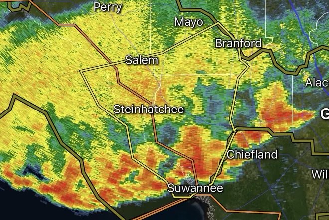
Impacted Areas: Northwestern Dixie County, Southwestern Lafayette County, and Southeastern Taylor County (Florida Big Bend region).
Core Threats: Damaging winds up to 60 mph, localized penny to nickel-sized hail, and torrential downpours causing sudden low-visibility or localized flooding.
Issuing Agency: National Weather Service (NWS) Tallahassee, FL.
Action Required: Seek shelter in a sturdy building immediately; stay away from windows and avoid flooded roadways.
The Florida Big Bend is no stranger to sudden, violent summer storms, and recent severe weather advisories have put residents on high alert. The National Weather Service (NWS) in Tallahassee frequently issues Severe Thunderstorm Warnings targeting Dixie, Lafayette, and Taylor counties, bringing heavy lightning, destructive winds, and intense rainfall to the region.
If you live in or are traveling through these areas, understanding the hazards and knowing how to respond can keep you and your family safe.
What Triggers a Severe Thunderstorm Warning in the Big Bend?
During the peak of Florida’s summer convective season, high heat and humidity combine with sea breezes crashing inland from both the Gulf of Mexico and the Atlantic. This creates a volatile atmosphere capable of producing rapid storm development.
When NWS meteorologists spot radar signatures indicating storms with specific criteria, a warning is immediately broadcast. For Dixie, Lafayette, and Taylor counties, these warnings are typically triggered by:
1. Damaging Winds: Wind gusts reaching or exceeding 60 mph. These speeds are strong enough to snap tree branches, uproot shallow-rooted trees, and cause localized power outages by downing utility lines.
2. Hail Threat: Hail ranging from penny (0.75 inches) to nickel/quarter size (up to 0.88–1.0 inch), which can dent vehicles and damage exterior siding or roofing.
3. Torrential Rainfall & Flash Flooding: Slow-moving or nearly stationary cells frequently dump inches of rain in a very short window, overwhelming poor drainage areas and rural roads.
Key Locations Vulnerable to These Storms
Storm tracks across the Big Bend frequently target specific rural hubs and communities along the coastal interfaces and inland corridors. Areas frequently impacted under these specific county alerts include:
Dixie County: Steinhatchee, Jena, Clara, and surrounding coastal/inland sectors.
Lafayette County: Mayo, Tennille, and southwestern rural zones.
Taylor County: Perry, Hampton Springs, Salem, and areas near the Perry-Foley Airport.
Because these storms often track slowly or stall out, rainfall accumulations can pile up quickly, turning routine afternoon showers into serious localized flood events.
Safety Checklist: How to Protect Your Property and Family
When a Severe Thunderstorm Warning is active for your area, every minute counts. Follow these essential safety guidelines:
Move Indoors Immediately: As the saying goes, “When thunder roars, go indoors.” Do not wait until the rain starts to seek safe shelter.
Secure Outdoor Objects: High winds can turn patio furniture, garbage cans, and unanchored lawn decorations into dangerous projectiles. Bring them inside or tie them down.
Stay Away from Windows: Flying glass is a major hazard during 60 mph wind gusts. Move to an interior room on the lowest floor of a sturdy building (such as a bathroom, hallway, or closet).
Never Drive Through Flooded Roads: Turn Around, Don’t Drown! Just a few inches of fast-moving water can sweep away a standard vehicle. Rural roads in Dixie, Lafayette, and Taylor counties can submerge rapidly under heavy downpours.
Prepare for Power Outages: Keep flashlights, extra batteries, and fully charged mobile devices close by. If you rely on well water, consider filling a few containers with emergency water beforehand.
Stay Informed
Weather conditions in North Florida can change in a matter of minutes. Always keep a NOAA Weather Radio tuned to your local frequency or enable emergency alerts on your smartphone to receive real-time updates directly from NWS Tallahassee.
Affiliate Disclosure: As an Amazon Associate, Radar Watch HQ earns from qualifying purchases.
Radar Watch HQ Top 5 Essential Emergency Preparedness Picks
Whether you’re preparing for severe thunderstorms, flash flooding, hurricanes, wildfires, or extended power outages, these five emergency essentials can help keep your household safer when severe weather strikes.
A portable power station provides reliable backup electricity during outages, allowing you to power phones, medical devices, laptops, lights, small appliances, and communication equipment without fuel.
Best for:
- Extended power outages
- Severe thunderstorms
- Hurricanes
- Winter storms
- Wildfires
2. Flood Protection Barriers & Sandless Flood Bags
Flood barriers help divert or absorb water before it enters garages, doorways, and low-lying areas. They deploy quickly and can help reduce property damage during flash flooding.
Best for:
- Flash Flood Warnings
- Heavy rainfall
- River flooding
- Coastal flooding
3. Rechargeable LED Flashlights
Bright, dependable flashlights are essential when the power goes out. Rechargeable or solar-powered models provide long-lasting illumination for navigating safely indoors and outdoors.
Best for:
- Overnight power outages
- Emergency evacuations
- Storm damage inspections
Keep phones, tablets, weather radios, and USB-powered devices charged when the electrical grid is unavailable. A solar power bank offers an additional charging option during prolonged emergencies.
Best for:
- Communication during outages
- Emergency weather alerts
- Travel and evacuation
A NOAA Weather Radio delivers official weather alerts directly from the National Weather Service, even when cellular networks or internet service are unavailable. It remains one of the most dependable ways to receive life-saving warnings.
Best for:
- Tornado warnings
- Severe thunderstorm warnings
- Flash flood warnings
- Hurricane alerts
- Winter storm emergencies
Why Radar Watch HQ Recommends These Essentials
At Radar Watch HQ, preparedness is just as important as staying informed. These five emergency essentials can help you stay connected, protect your property, and safely navigate severe weather events. Having supplies ready before storms arrive allows you to respond quickly when warnings are issued and conditions begin to deteriorate.