Three Pacific Tropical Disturbances Under Watch
August 10, 2026 — Forecasters are monitoring several areas of disturbed weather across the Central and Eastern Pacific, with the strongest development potential currently focused on a broad area of low pressure east-southeast of the Hawaiian Islands.
While none of the systems described below is currently a tropical depression, environmental conditions could allow some of them to organize over the coming days.
Central Pacific System Has the Highest Development Potential
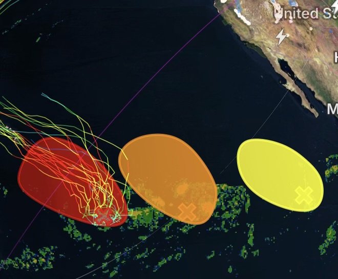
A broad area of low pressure is located approximately 1,100 miles east-southeast of the Hawaiian Islands. The system is producing disorganized showers and thunderstorms and is currently moving very little.
However, conditions around the disturbance are expected to become increasingly favorable for organization.
The system is forecast to begin moving west-northwestward or northwestward across the Central Pacific. As it does, additional thunderstorms could become better organized around the circulation.
Tropical Depression Possible by Midweek
A tropical depression could form by the middle of the week if the system continues to consolidate.
Current formation probabilities:
- Next 48 hours: 50% — Medium
- Next 7 days: 90% — High
The high seven-day probability makes this disturbance the primary tropical feature to watch in the Central Pacific.
Hawaii residents and interests should continue monitoring future forecasts, especially as the system’s movement becomes better established.
Western Eastern Pacific Disturbance Also Being Monitored
Another large area of disorganized showers and thunderstorms is located well west-southwest of the southern tip of the Baja California Peninsula.
Environmental conditions appear favorable for some gradual development during the next several days.
The disturbance is expected to move slowly west-northwestward to northwestward across the western portion of the Eastern Pacific.
Gradual Development Possible
Although development is expected to be slow, the system could eventually become organized enough to form a tropical depression.
Current formation probabilities:
- Next 48 hours: 30% — Low
- Next 7 days: 60% — Medium
This system will be worth watching as it moves farther across the Pacific and encounters changing atmospheric conditions.
Tropical Wave Southwest of Mexico Has Limited Potential
A third area of disorganized showers and thunderstorms is located several hundred miles south-southwest of the southern tip of the Baja California Peninsula.
The activity is associated with a tropical wave moving west-northwestward at approximately 15 mph.
For now, environmental conditions are only marginally favorable for development.
Strong Upper-Level Winds Could Shut Down Development
The disturbance could experience a brief window for slow organization during the next day or two. However, by late Tuesday or Wednesday, the system is expected to reach an area of stronger upper-level winds.
Those winds are expected to become increasingly hostile to tropical development, significantly reducing the disturbance’s chances of organizing.
Current formation probabilities:
- Next 48 hours: 10% — Low
- Next 7 days: 10% — Low
At this time, the third disturbance has substantially less development potential than the systems farther west across the Pacific.
Which Pacific System Has the Greatest Potential?
Of the three disturbances being monitored, the Central Pacific low-pressure system currently stands out as the most likely to become a tropical depression.
| Area | 48-Hour Chance | 7-Day Chance | Overall Potential |
| Central Pacific | 50% | 90% | High |
| Western Eastern Pacific | 30% | 60% | Medium |
| Southwest of Mexico | 10% | 10% | Low |
The Central Pacific disturbance deserves the closest attention because its seven-day development probability is significantly higher than the other two systems.
What to Watch This Week
The next several days will be important as the disturbances encounter different atmospheric environments.
Forecasters will be watching for:
- Increasing organization of thunderstorms
- Development of a defined circulation
- Changes in forward movement
- Strengthening or weakening of upper-level winds
- Increasing or decreasing tropical development probabilities
- Potential tropical depression formation in the Central Pacific
For Hawaii, Baja California, Mexico and surrounding Pacific interests, conditions can change quickly during tropical development. A disturbance can strengthen, weaken or change direction as environmental conditions evolve.
Radar Watch HQ Tropical Weather Update
The Pacific remains active, and the Central Pacific disturbance is the feature to watch most closely right now. With a 90% chance of development over the next seven days, the system could become a tropical depression by midweek as it begins moving west-northwestward or northwestward.
Meanwhile, a second disturbance west-southwest of Baja California has a moderate chance of gradual development, while the tropical wave southwest of Mexico currently has only a small chance of organizing before stronger upper-level winds interfere.
Stay weather-aware and continue checking Radar Watch HQ for developing tropical threats, updated forecasts and important changes across the Pacific.