Atlantic Tropical Development Increasing This Week
The tropical Atlantic is becoming increasingly active, with three separate areas of disturbed weather being monitored across the basin. While none of the systems has a high short-term chance of development, one disturbance south of the Cabo Verde Islands could become more organized later this week.
Forecasters are watching how these systems interact with their surrounding environment, including atmospheric moisture, upper-level winds and ocean temperatures.
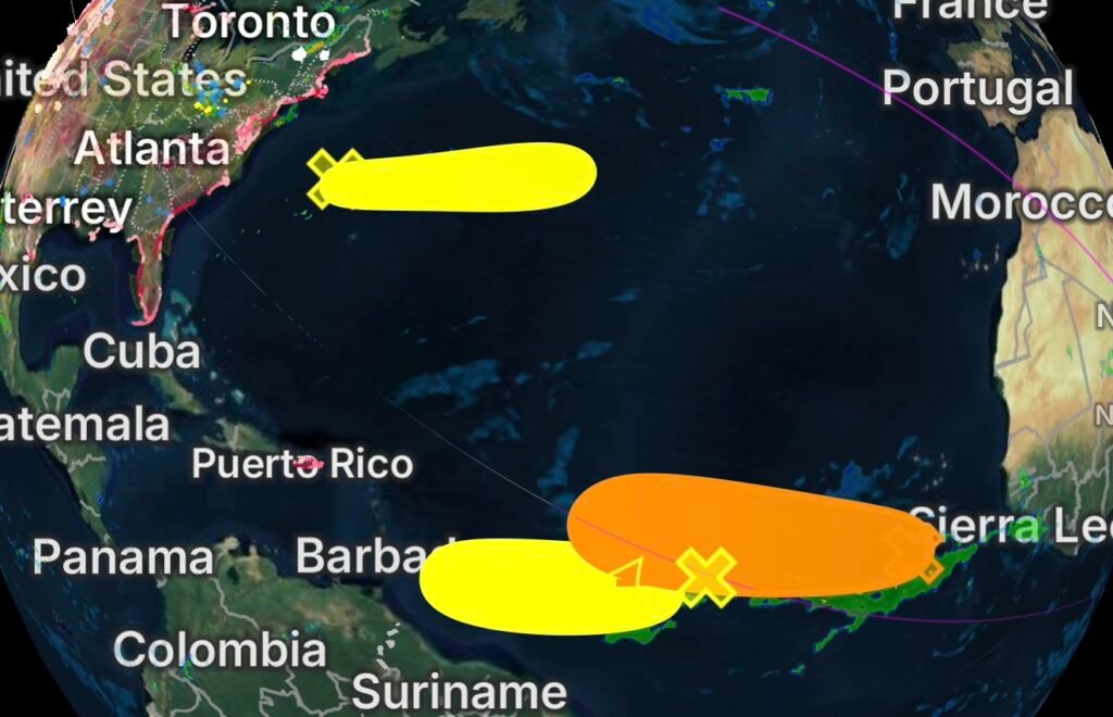
The most notable area currently has a 60% chance of tropical development over the next seven days.
Eastern and Central Tropical Atlantic: Highest Development Potential
An area of low pressure located a few hundred miles south of the Cabo Verde Islands is producing disorganized showers and thunderstorms.
For now, the system remains poorly organized. However, conditions are expected to become more favorable by the middle of the week.
As the low pressure area moves slowly westward, a tropical wave currently moving across West Africa is expected to merge with the system in a couple of days.
Development Could Increase Later This Week
The combination of these disturbances could help the system become better organized. Environmental conditions are forecast to become more conducive for development by midweek.
As a result, a tropical depression could form during the latter half of this week.
The system is expected to generally move westward to west-northwestward across the central tropical Atlantic.
Formation Chances
- Through 48 hours: 20% — Low
- Through 7 days: 60% — Medium
This is currently the primary area of interest in the Atlantic based on the longer-term development potential.
Central Tropical Atlantic: Tropical Wave Being Monitored
A broad area of showers and thunderstorms associated with a tropical wave is located about midway between the coast of West Africa and the Lesser Antilles.
The disturbance is moving quickly westward across the central tropical Atlantic.
Some gradual development is possible through midweek as the system continues westward.
Conditions May Become Less Favorable
Although some organization could occur during the next few days, upper-level winds are expected to become increasingly unfavorable later in the week.
That could limit the system’s ability to strengthen as it approaches the Lesser Antilles.
At this time, development probabilities remain low.
Formation Chances
- Through 48 hours: 10% — Low
- Through 7 days: 10% — Low
Despite the low probabilities, the system will remain worth watching because of its westward movement across the tropical Atlantic.
Western Subtropical Atlantic: System Moving East
Farther west, a trough of low pressure located a few hundred miles northwest of Bermuda is producing disorganized showers and thunderstorms.
Some development is possible during the next couple of days as the system moves quickly eastward, remaining well north of Bermuda.
The disturbance is expected to track across the western and central subtropical Atlantic.
Cooler Waters Expected to End Development Chances
The system is forecast to reach cooler ocean waters later this week. Consequently, its chances for tropical or subtropical development should decrease and eventually end after Wednesday.
Formation Chances
- Through 48 hours: 10% — Low
- Through 7 days: 10% — Low
At this point, this system has a much lower development potential than the disturbance south of the Cabo Verde Islands.
What to Watch Across the Atlantic
The Atlantic basin has several disturbances worth monitoring this week, but not all tropical waves or areas of thunderstorms become tropical depressions or named storms.
The primary feature to watch is the low pressure area south of the Cabo Verde Islands. Its potential interaction with a tropical wave emerging from West Africa could provide an opportunity for organization as conditions improve.
Meanwhile, the central tropical Atlantic wave has a limited window for development before upper-level winds become less supportive. The western subtropical disturbance faces increasingly cooler waters later this week.
Atlantic Development Snapshot
| Area | 48-Hour Chance | 7-Day Chance | Main Concern |
| South of Cabo Verde Islands | 20% | 60% | Potential tropical depression later this week |
| Central Tropical Atlantic | 10% | 10% | Fast westward movement; unfavorable winds later |
| Northwest of Bermuda | 10% | 10% | Cooler waters after Wednesday |
Stay Ahead of Tropical Weather
The tropical Atlantic can change quickly, particularly when multiple disturbances are present at the same time. A low development probability today does not necessarily mean conditions will remain unchanged several days from now.
For now, the 60% seven-day development chance south of the Cabo Verde Islands is the feature receiving the most attention.
Radar Watch HQ will continue monitoring tropical development, storm organization and potential changes to forecast tracks and formation probabilities as the week progresses.
Stay weather-aware, keep alerts enabled, and check back with Radar Watch HQ for the latest tropical Atlantic updates.