Tropical Depression Forms Over the Gulf
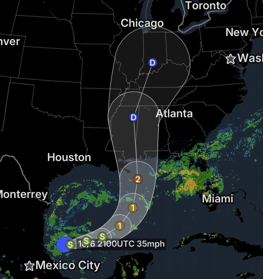
A Tropical Depression has formed over the Gulf of Mexico, approximately 380 miles west of Progreso, Mexico, marking another important development during the active 2026 Atlantic hurricane season.
The system is producing organized showers and thunderstorms and is being monitored closely as it moves across the Gulf.
Although the depression is currently not a hurricane or tropical storm, tropical systems can strengthen quickly under favorable conditions, making continued monitoring important for communities along the Gulf Coast.
Gulf Coast Interests Should Monitor the Forecast
The depression’s development comes as residents along the northern Gulf Coast remain attentive to changing tropical conditions.
Forecast uncertainty remains regarding the system’s eventual track, intensity and specific impacts. Depending on how the system develops and moves, portions of the Gulf Coast could experience:
- 🌧️ Heavy rainfall
- 💨 Gusty winds
- 🌊 Rough surf and elevated seas
- 🌴 Coastal flooding
- ⚠️ Dangerous rip currents
- 🌧️ Localized flash flooding
Residents should rely on official forecasts as the system becomes better organized and its projected track becomes clearer.
Heavy Rain Could Become a Major Concern
Tropical depressions can produce significant rainfall even when wind speeds remain relatively modest.
Heavy tropical downpours may lead to poor drainage flooding, flash flooding and hazardous travel, particularly in areas that receive repeated thunderstorms.
Rainfall impacts can also extend well away from the center of circulation.
Coastal Conditions May Deteriorate
As the system develops, conditions across portions of the Gulf could become increasingly hazardous for mariners.
Increasing winds can create rough seas and dangerous conditions for smaller vessels, while tropical swells may spread outward from the system.
Beachgoers should also watch for changing surf and rip-current conditions if the system approaches coastal areas.
Is the Depression Expected to Strengthen?
A tropical depression can strengthen into a tropical storm when environmental conditions become favorable.
Forecasters will be watching several factors, including:
- Sea-surface temperatures
- Wind shear
- Thunderstorm organization
- The system’s overall circulation
- Its forward movement and interaction with surrounding weather patterns
If sustained winds reach 39 MPH, the system would be classified as a tropical storm and receive an official name.
Essentials: What Gulf Coast Residents Should Do
🌧️ Monitor rainfall forecasts: Tropical systems can produce flooding even without a direct landfall.
🚗 Avoid flooded roads: Turn around, don’t drown!
🌊 Stay alert along the coast: Rough surf, rip currents and coastal flooding can become dangerous quickly.
🚤 Mariners should use caution: Check the latest marine forecast before heading onto the Gulf.
📱 Follow official updates: Keep track of National Hurricane Center and National Weather Service advisories as the system evolves.
🌀 Don’t focus only on the center: Tropical weather impacts can extend far from the center of circulation.
Bottom Line
A Tropical Depression has formed over the Gulf of Mexico about 380 miles west of Progreso, Mexico, on October 6, 2026. While the system is currently below tropical-storm strength, its development could bring increasing rain, wind and marine hazards across portions of the Gulf.
The system’s future track and strength will determine which areas face the greatest impacts. Gulf Coast residents should continue monitoring official forecasts for updates.