Coastal Hazards to Watch as Dolly Moves Across the Tropical Atlantic
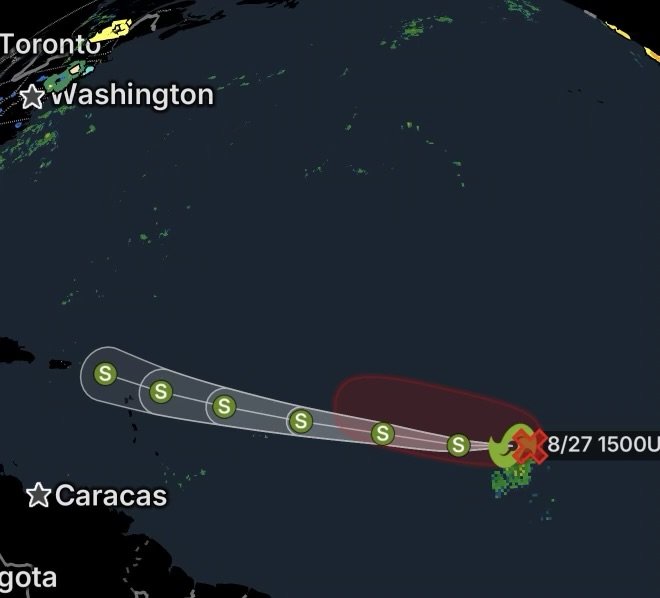
Tropical Storm Dolly has formed over the central tropical Atlantic, after satellite imagery showed an area of low pressure becoming better organized overnight. The National Hurricane Center initiated advisories Thursday morning, August 27, 2026. (National Hurricane Center)
Dolly is currently far from the United States and other major land areas. However, interests across the Lesser Antilles and Windward Islands should continue monitoring the forecast, because even a short-lived tropical cyclone can produce dangerous marine conditions, heavy rainfall and localized coastal impacts. (AccuWeather)
Tropical Storm Dolly: What Happens Next?
The system developed from a low-pressure area located roughly midway between Africa and the Windward Islands. Earlier Thursday, forecasters noted that continued organization could lead to a short-lived tropical storm. That scenario has now occurred.
However, Dolly’s opportunity to strengthen appears limited. Environmental conditions are expected to become increasingly hostile beginning Friday, which should reduce the storm’s ability to maintain a well-organized circulation. (NBC Miami)
Wind Shear Could Quickly Weaken Dolly
One of the biggest challenges for Dolly will be increasing vertical wind shear. Strong winds at different levels of the atmosphere can tilt a tropical cyclone’s circulation, separate thunderstorms from its center and prevent further strengthening.
As a result, Dolly could remain a relatively weak and short-lived tropical cyclone.
What Coastal Hazards Should Residents Prepare For?
Even if Dolly does not become a strong tropical storm, residents and marine interests should not ignore the possibility of impacts from the storm’s rainbands and surrounding circulation.
🌧️ Heavy Rainfall and Localized Flooding
Tropical moisture can produce periods of heavy rainfall even when a storm is weakening.
Residents in the Lesser Antilles should be alert for:
- Brief periods of torrential rain
- Street and poor-drainage flooding
- Rapid rises in small streams
- Ponding of water on roads
- Reduced visibility for motorists
- Isolated mudslides in steep or mountainous terrain
The heaviest rainfall will depend on Dolly’s eventual track and how much of the storm’s circulation survives.
🌊 Rough Surf and Dangerous Coastal Waters
One of the more immediate concerns can be rough seas and elevated surf.
Dolly’s circulation may generate:
- Higher waves
- Choppy coastal waters
- Dangerous conditions for swimmers
- Stronger currents
- Hazardous conditions near reefs and rocky shorelines
- Difficult conditions for small boats
Even when winds remain below hurricane strength, tropical systems can create dangerous ocean conditions.
🏖️ Rip Currents
Beachgoers should also be aware of the potential for stronger rip currents.
A beach may appear relatively calm while offshore swell and changing wave conditions create powerful currents capable of pulling swimmers away from shore.
If local officials post swimming restrictions or beach warnings, follow them.
⛵ Marine Hazards for Small Craft
Boaters should closely monitor marine forecasts as Dolly approaches the eastern Caribbean.
Potential concerns include:
- Sudden wind gusts
- Squalls and thunderstorms
- Reduced visibility
- Rapidly changing sea conditions
- Higher waves and seas
- Lightning
- Dangerous conditions for smaller vessels
Thunderstorms embedded within tropical rainbands can produce stronger wind gusts than the broader storm circulation.
Which Areas Should Watch Dolly?
The Windward Islands and Lesser Antilles are the primary areas that should keep monitoring Dolly’s latest forecasts as the system moves westward.
At this time, Dolly is not being described as a direct threat to the mainland United States. Forecast confidence, however, can change as a tropical cyclone interacts with its surrounding environment.
Because tropical systems can weaken, reorganize or change direction, residents should rely on the latest official forecasts rather than older storm tracks.
What Residents Can Do Now
There is no reason for widespread coastal panic based solely on Dolly’s current status. However, residents in potentially affected islands can take simple precautions.
Before Conditions Deteriorate
Secure loose outdoor objects, check drainage around your property, charge essential devices and review local emergency information.
Beach and boating plans should remain flexible, especially if marine conditions begin deteriorating.
During Heavy Rain
Avoid driving through flooded roadways. Water can hide damaged pavement, debris or areas where the road has been washed away.
Residents in flood-prone locations should monitor local authorities for evacuation or shelter information.
For Boaters
Check updated marine forecasts before leaving port. Small craft should avoid entering deteriorating conditions simply because the storm remains below hurricane strength.
Radar Watch HQ Weather Watch
Tropical Storm Dolly is a reminder that storm strength is only one part of the coastal-weather threat. Heavy rain, rough seas, rip currents, thunderstorms and sudden wind gusts can create dangerous conditions even from a relatively weak tropical cyclone.
Dolly is expected to encounter increasingly unfavorable conditions beginning Friday, potentially limiting its lifespan and intensity. (NBC Miami)
Still, residents across the Lesser Antilles should continue watching official forecasts for changes in the storm’s track, rainfall and marine conditions.
Radar Watch HQ Final Thoughts
Tropical Storm Dolly may be short-lived, but that does not mean its weather effects should be ignored. Coastal residents should prepare for heavy rainfall, localized flooding, rough surf, stronger currents, thunderstorms and hazardous marine conditions.
The most important step is staying informed. Conditions can change quickly in the tropics, so continue checking the National Hurricane Center and local emergency-management agencies for the latest information.
Stay weather-aware, stay prepared, and never underestimate rapidly changing coastal conditions.