


















Coastal and Flash Flood Threat Expands Across the Mid-Atlantic
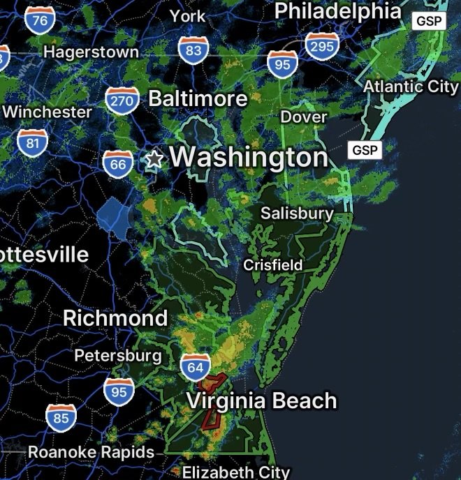
A broad flooding threat is affecting portions of the Mid-Atlantic on September 22, with the National Weather Service highlighting both coastal flooding and flash flooding across Maryland, New Jersey and Virginia.
The coastal threat is being driven by rising water levels along shorelines and tidal waterways. Several areas could experience roadway flooding, inundation of low-lying property and shoreline erosion, particularly around high tide.
Meanwhile, active Flash Flood Warnings indicate a more immediate concern in portions of southeastern Virginia, where rapidly rising water can make roads and low-lying areas dangerous with little notice.
Coastal Flooding Across Maryland
A Coastal Flood Watch is in effect for Dorchester, Wicomico and Somerset Counties in Maryland. The National Weather Service says one to two feet of inundation above ground level is possible in low-lying areas near shorelines and tidal waterways. The watch is in effect from Wednesday evening through late Thursday night. (National Weather Service)
Residents in vulnerable locations should prepare for the possibility of flooded roads and property, especially during periods of high tide. Some critical infrastructure could also be affected.
New Jersey Coastal Flood Watch
In New Jersey, a Coastal Flood Watch covers:
- Ocean County
- Atlantic County
- Cape May County
- Southeastern Burlington County
The National Weather Service indicates one to two feet of inundation above ground level is possible in low-lying areas near shorelines and tidal waterways during the watch period, which begins Wednesday afternoon and continues through late Thursday night. (National Weather Service)
A coastal flood advisory is also in effect today for portions of the New Jersey coast, with additional concerns including high surf and a high rip-current risk.
Virginia’s Northern and Middle Chesapeake Bay Shorelines
A Coastal Flood Watch covers Westmoreland, Richmond, Northumberland, Lancaster, Middlesex, Mathews, Western Essex and Eastern Essex Counties.
The National Weather Service says one to three feet of inundation above ground level is possible in low-lying areas near shorelines and tidal waterways. The watch extends from late Tuesday night through Friday morning. (National Weather Service)
An ongoing coastal flood advisory also calls for up to one foot of inundation in vulnerable locations before the longer-duration watch begins.
Residents near tidal waterways should be prepared for water to spread onto roads and into normally dry areas, particularly around high tide.
Coastal Flooding From Surry to Isle of Wight County
Another significant coastal flood threat covers Surry, James City, Newport News and Isle of Wight Counties.
A coastal flood advisory is in effect this evening into Wednesday morning, followed by a Coastal Flood Watch from Wednesday morning through late Thursday night. The National Weather Service says two to three feet of inundation above ground level is possible in low-lying areas near shorelines and tidal waterways during the watch. (National Weather Service)
Numerous roads could become flooded, while low-lying homes, businesses and critical infrastructure may be affected. Shoreline erosion is also possible.
Flash Flood Warnings in Southeastern Virginia
More immediate flooding concerns are present across portions of southeastern Virginia, where Flash Flood Warnings include southern York County, the City of Newport News and the City of Poquoson.
Additional Flash Flood Warning coverage includes communities and areas identified as Churchland, Driver, Western Branch, Bowers Hill, Diane’s, Huntersville and Wilroy.
Flash flooding can develop quickly when heavy rainfall overwhelms drainage systems, streams and low-lying areas. Water may rise rapidly on streets and in areas that normally remain dry.
Drivers should take particular care during active warnings. Never drive through flooded roadways or around barricades. Even shallow-looking water can conceal washed-out pavement, debris or dangerous currents.
Coastal Flooding and Flash Flooding Require Different Responses
Although both hazards involve flooding, the timing and behavior can be different.
Coastal flooding is closely tied to tides, water levels, onshore winds and coastal conditions. It can repeatedly affect the same low-lying locations during high tide and may worsen over multiple tidal cycles.
Flash flooding can develop much more rapidly, sometimes leaving little time to react. Heavy rainfall can quickly overwhelm drainage systems and cause dangerous water rises on roads, streams and low-lying terrain.
That means residents under a Coastal Flood Watch should use the lead time to prepare, while anyone inside a Flash Flood Warning area should be ready to move to higher ground immediately if flooding threatens their location.
Travel Safety During the Flood Threat
Flooding can make ordinary travel routes dangerous or impassable.
Before traveling, check current road conditions and weather information. If water begins covering a roadway, turn around and find another route rather than attempting to cross it.
Remember:
- Do not drive through flooded roads.
- Do not drive around barricades.
- Avoid areas where water is rapidly rising.
- Allow additional travel time where coastal flooding is expected.
- Move vehicles and important belongings away from flood-prone areas when possible.
- Follow instructions from local emergency management and public safety officials.
- If water begins entering a building, move to a safer location and follow local emergency guidance.
What Residents Should Watch For
The combination of coastal and flash flooding means conditions can change considerably from one community to another. A location outside an active warning can still experience localized flooding if heavy rainfall or rising tidal water affects the area.
Residents should continue monitoring updated National Weather Service information and local emergency alerts, especially through periods of high tide and heavy rainfall.
For coastal communities, the primary concern is rising water in low-lying areas and along tidal waterways. For areas under Flash Flood Warnings, the concern is rapidly developing water that can make roads and low-lying areas dangerous with little warning.
Radar Watch HQ Final Thoughts
The September 22 flooding threat spans multiple states and includes both longer-duration coastal flooding concerns and more immediate flash-flood hazards.
Residents along vulnerable Maryland, New Jersey and Virginia shorelines should prepare for rising water and possible road closures, while communities under Flash Flood Warnings in southeastern Virginia should treat those warnings as an immediate safety concern.
Stay weather aware, avoid flooded roadways, and never assume a familiar route is safe simply because it was passable earlier.
For the latest official warning information, continue monitoring the National Weather Service and local emergency officials as conditions evolve.