
















Severe Coastal Weather Threat Expands From New Jersey to Long Island
A powerful coastal weather system is bringing an extended period of hazardous conditions to the waters and shorelines of New Jersey and New York. The National Weather Service is monitoring storm-force winds offshore, dangerous surf conditions, high rip-current risk and coastal flooding as the system strengthens through the end of the week.
For boaters, beachgoers and residents in vulnerable coastal locations, conditions can deteriorate quickly. The greatest concerns include rough seas offshore, strong northeast winds, dangerous currents in the surf zone and repeated tidal flooding along portions of the Jersey Shore.
Storm Watch Covers Offshore Waters From Sandy Hook to Montauk Point
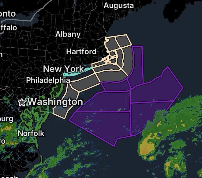
A Storm Watch is in effect from Thursday evening through Friday afternoon for waters extending 20 to 60 nautical miles offshore from Sandy Hook, New Jersey, toward Long Island and Montauk Point. The affected offshore zones include waters from Sandy Hook to Fire Island, Fire Island to Moriches Inlet, and Moriches Inlet to Montauk Point.
During the Storm Watch period, the National Weather Service says northeast winds could reach 30 to 40 knots, with gusts up to 55 knots, while seas could build to 13 to 17 feet in the affected waters. These conditions can create dangerous conditions for even experienced mariners.
The Storm Watch follows an existing Gale Warning, meaning hazardous marine conditions are already developing before the potential storm-force conditions arrive.
Mariners should consider remaining in port, seeking safe harbor or securing vessels before conditions become more dangerous. Strong winds and large seas can make navigation difficult, reduce visibility and create a serious risk of capsizing or vessel damage.
Dangerous Rip Currents Threaten New York Beaches
The marine threat is also reaching the shoreline.
A High Rip Current Risk is in effect through Thursday afternoon for Kings (Brooklyn), Southwest Suffolk, Southeast Suffolk and Southern Queens counties.
Rip currents can pull swimmers away from shore into deeper water, including experienced swimmers who may underestimate the strength of the current.
Beachgoers should stay out of the surf when dangerous conditions are present and follow instructions from lifeguards and local officials. Anyone caught in a rip current should remain calm, float and avoid trying to swim directly against the current. When possible, swimming parallel to the shoreline can help a person move out of the current.
The combination of stronger winds, elevated seas and persistent wave activity can make beach conditions particularly hazardous.
Coastal Flood Warning Covers Four Southern New Jersey Counties
A Coastal Flood Warning is in effect for Ocean, Atlantic, Cape May and Southeastern Burlington counties from 4 p.m. Wednesday through 2 a.m. Saturday.
The National Weather Service expects approximately 1 to 2 feet of inundation above ground level in vulnerable areas near shorelines and tidal waterways.
This level of flooding can produce widespread roadway flooding in coastal and bayside communities. Some roads may become impassable, while vulnerable structures could begin experiencing damage.
Residents should avoid driving through flooded roads. Water depth can be difficult to judge, and road conditions can change rapidly as tides rise and waves push additional water into coastal communities.
Why the Coastal Threat Is Increasing
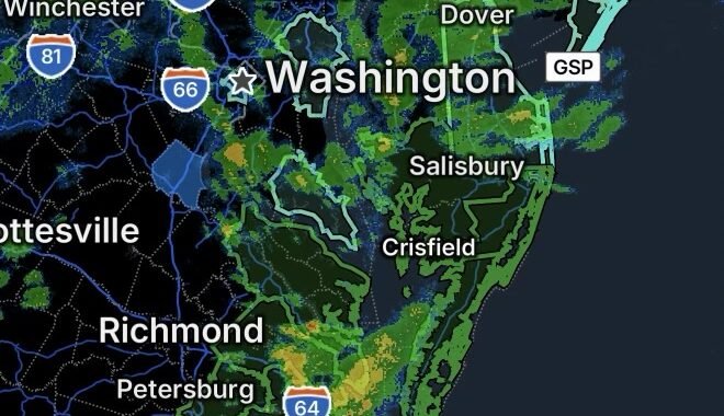
The evolving weather pattern involves strengthening high pressure to the north and a developing low-pressure system tracking across the western Atlantic. The National Weather Service notes that uncertainty remains regarding the exact track of the coastal low, but a close enough passage could produce increasingly hazardous conditions along the Mid-Atlantic coast.
For coastal areas, the combination of strong northeast winds, elevated seas, wave action and high astronomical tides can create impacts well beyond the immediate storm center.
This is especially important when coastal flooding and dangerous surf occur at the same time. Water pushed toward the shoreline by persistent onshore winds can worsen flooding during high tide cycles.
What Residents, Boaters and Beachgoers Should Do
For coastal residents:
- Move vehicles away from locations known to flood.
- Monitor changing tide and weather conditions.
- Avoid flooded roads and never drive around barricades.
- Secure loose outdoor objects before winds increase.
- Be prepared for repeated rounds of coastal flooding.
For boaters:
- Consider remaining in port while hazardous marine conditions continue.
- Secure vessels and equipment before winds strengthen.
- Do not underestimate rapidly building seas.
- Monitor updated marine forecasts and warnings.
For beachgoers:
- Stay out of the surf when dangerous rip currents are present.
- Swim only where lifeguards are present when swimming is permitted.
- Follow beach closures and local safety instructions.
- Never attempt to fight a rip current by swimming directly against it.
Radar Watch HQ Final Thoughts
The coastal weather threat from New Jersey through Long Island is expected to remain elevated through the end of the week. Offshore waters face the potential for storm-force winds and very rough seas, while beaches face dangerous rip currents and portions of the Jersey Shore face prolonged coastal flooding.
Conditions can change as the coastal system develops, so residents, boaters and beach visitors should continue monitoring the latest National Weather Service updates and local emergency information before heading to the coast.
Stay weather-aware, stay out of dangerous surf, and never drive through flooded roadways.