














Flood Watches and Warnings Remain in Effect as Rivers, Creeks and Low-Lying Areas Face Continued Flooding
A significant flooding threat continues across parts of Ohio, Pennsylvania and West Virginia as periods of heavy rain and thunderstorms have produced excessive runoff, rising waterways and flooded roads.
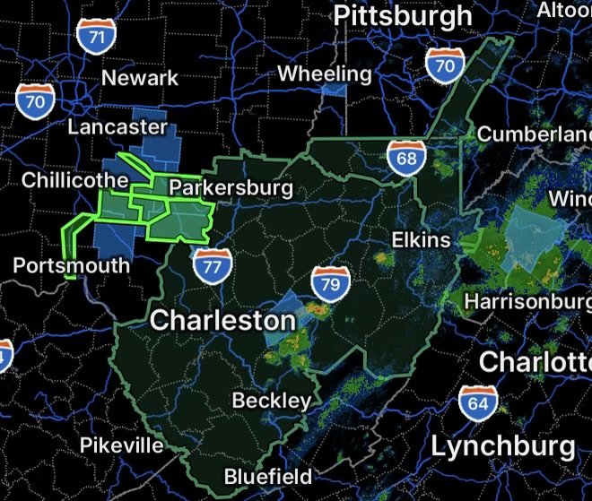
The National Weather Service has Flood Watches covering portions of southwest Pennsylvania, northern West Virginia and southeast Ohio, while multiple Flood Warnings remain in effect across southeastern Ohio and portions of western West Virginia. River flooding is also occurring along the Scioto River at Piketon and Hocking River at Enterprise. (National Weather Service)
Areas that have already received significant rainfall are particularly vulnerable to additional flooding. Slow-moving showers and thunderstorms can quickly increase runoff, especially where the ground is saturated and drainage systems, creeks and smaller streams are already overwhelmed.
Flood Watch: Southwest Pennsylvania and Northern West Virginia
A Flood Watch remains in effect across portions of southwest Pennsylvania and northern West Virginia, with excessive rainfall capable of producing flash flooding.
The broader watch area includes portions of the Pittsburgh region and surrounding areas, extending into parts of northern and central West Virginia. Locations within the watch should remain alert for rapidly changing conditions, particularly near creeks, streams, drainage channels and low-lying roads. (National Weather Service)
A Flood Watch means flooding is possible. It does not mean every location within the watch area will flood, but conditions are favorable enough that residents should be prepared to act if warnings are issued.
Flood Watch: Southeast Ohio
Portions of southeast Ohio are also under a Flood Watch as additional excessive rainfall remains possible.
The National Weather Service warns that slow-moving showers and thunderstorms could continue to move across the region, with previously saturated areas more vulnerable to additional flooding. Excessive runoff may cause flooding along rivers, creeks, streams and other low-lying locations. (National Weather Service)
Residents should avoid assuming that a location is safe simply because rainfall has temporarily stopped. Water can continue rising after heavy rain moves away, particularly downstream from areas that received the heaviest rainfall.
Flood Warnings Across Southeastern Ohio and Western West Virginia
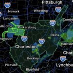
Flood Warnings are in effect for several areas where flooding is occurring or is imminent.
Southeastern Athens County, Ohio
Northeastern Gallia County, Ohio
Meigs County, Ohio
Southwestern Washington County, Ohio
Northwestern Jackson County, West Virginia
Western Wood County, West Virginia
North Central Mason County, West Virginia
The National Weather Service has reported significant flooding from excessive rainfall across these areas, with rivers, creeks, streams and other flood-prone locations affected. (National Weather Service)
Residents in warned areas should take flooding seriously and avoid traveling through water-covered roadways.
Additional Flood Warning Areas in Southeast Ohio
Another Flood Warning covers portions of Athens, Meigs and Vinton counties.
The affected areas include:
- Northern Jackson County in southeastern Ohio
- Northwestern Meigs County in southeastern Ohio
- Northern Vinton County in southeastern Ohio
The National Weather Service previously reported numerous flooded roads in parts of the region following heavy rain and thunderstorms. (National Weather Service)
Flooding can change quickly, particularly on smaller streams and creeks. Roads that were passable earlier can become dangerous or completely impassable within a short period of time.
Scioto River at Piketon Under Flood Warning
The Scioto River at Piketon remains under a Flood Warning for minor flooding.
The National Weather Service reported that the river was already experiencing minor flooding and was forecast to rise further before eventually falling below flood stage. At the reported forecast point, several roads near the river can become flooded, including county roads near creeks flowing into the Scioto River. (National Weather Service)
Residents near the river and nearby tributaries should monitor water levels and avoid flooded roads.
Hocking River at Enterprise Under Flood Warning
The Hocking River at Enterprise is also under a Flood Warning.
Minor flooding is occurring or forecast, with flooding possible along portions of the river and nearby low-lying areas. (National Weather Service)
River flooding can continue even after the most intense rainfall has ended because water from upstream areas continues moving downstream.
Why Additional Rainfall Matters
The biggest concern is not necessarily one individual thunderstorm. Repeated rounds of rainfall over areas that have already received heavy precipitation can produce increasingly significant runoff.
When soil becomes saturated, less rainfall can soak into the ground. More water instead flows across the surface into drainage systems, creeks and rivers. This can cause water levels to rise quickly and can overwhelm roads, culverts and drainage infrastructure.
Residents should pay particular attention to:
- Creeks and small streams
- Low-water crossings
- Areas near rivers
- Flood-prone roads
- Poorly drained neighborhoods
- Areas that have already received heavy rainfall
- Roads near rising waterways
Flood Safety: Never Drive Through Floodwater
If you encounter a flooded roadway, turn around and find another route.
Do not drive around barricades or attempt to cross water simply because another vehicle made it through. Floodwater can hide washed-out pavement, debris, deep holes and damaged roadways. Moving water can also push vehicles off the road.
The National Weather Service emphasizes that most flood deaths occur in vehicles. (National Weather Service)
If water is approaching your vehicle, move to higher ground when it is safe to do so.
What Residents Should Do Now
If you live in or are traveling through an area under a Flood Watch:
- Monitor updated forecasts and local emergency information.
- Be prepared for Flood Warnings to be issued.
- Know which roads and low-lying areas commonly flood.
- Avoid unnecessary travel during periods of intense rainfall.
- Never drive through flooded roadways.
- Move away from rapidly rising creeks and streams.
- Keep children and pets away from floodwater.
- Take Flood Warnings seriously and be prepared to move to higher ground if necessary.
If you are already inside a Flood Warning area, conditions can deteriorate quickly. Do not wait until water is surrounding your home or vehicle before deciding what to do.
Radar Watch HQ Final Thoughts
The combination of saturated ground, additional rainfall and rising waterways makes this an evolving flood situation across parts of Ohio, Pennsylvania and West Virginia.
With Flood Watches covering additional areas and Flood Warnings already in effect across multiple counties and river locations, residents should remain weather-aware throughout the day. Flooding does not always happen where the heaviest rain is falling at that exact moment, and water can continue moving downstream after storms pass.
Stay alert, avoid flooded roads, and remember: Turn around, don’t drown.