Eastern Pacific Tropical Threat Grows: New System, Karina and Lowell
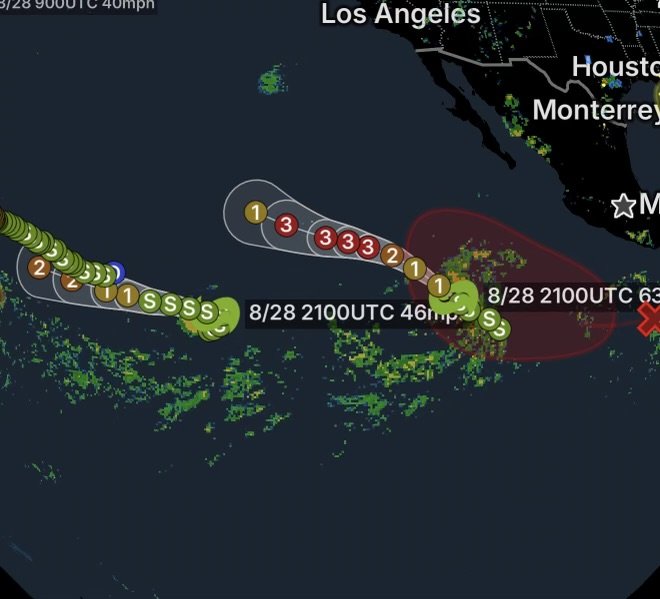
The eastern Pacific is becoming increasingly active, with Tropical Storm Karina, Tropical Storm Lowell, and another developing tropical disturbance being monitored by the National Hurricane Center (NHC). While the newest system remains well offshore, environmental conditions are becoming favorable for gradual development.
For residents and coastal interests across southwestern Mexico, Baja California, and portions of the Pacific, the developing pattern is worth watching closely. At this time, the newest disturbance is expected to remain well offshore, but increasing winds and seas could eventually affect marine conditions.
New Tropical Disturbance South of Southwestern Mexico
An area of disturbed weather associated with a tropical wave is located well south of southwestern Mexico.
According to the latest NHC Tropical Weather Outlook, environmental conditions appear favorable for gradual development. A tropical depression is likely to form early next week as the system moves west-northwestward to northwestward at 10 to 15 mph.
The NHC currently gives the disturbance a 20% chance of formation during the next 48 hours and an 80% chance of formation within seven days.
Why Development Is Possible
Several atmospheric and oceanic ingredients can support tropical cyclone formation. When thunderstorms remain organized near a developing area of low pressure, warm ocean water can provide additional energy while favorable upper-level winds allow the circulation to become better defined.
Because the system is expected to move generally westward or west-northwestward, it may remain over warm Pacific waters for an extended period. Consequently, gradual strengthening is possible.
However, tropical forecasts can change significantly several days in advance, especially when a system is still developing.
Tropical Storm Karina
Tropical Storm Karina is currently the stronger of the two named storms in the eastern Pacific.
The latest NHC analysis places Karina well south-southwest of the southern tip of the Baja California Peninsula. The storm is moving northwest and is forecast to turn more westward later.
Karina is forecast to strengthen substantially and could become a major hurricane while remaining well offshore of southwestern Mexico.
Dangerous Surf and Rip Currents Possible
Even though Karina is expected to remain offshore, its effects will not necessarily stay confined to the open ocean.
The NHC warns that swells generated by Karina are expected to reach portions of southwestern Mexico and the Baja California Peninsula this weekend. Those swells could produce dangerous surf and life-threatening rip currents.
Beachgoers should therefore avoid assuming that offshore distance means no coastal impacts.
Tropical Storm Lowell
Farther west, Tropical Storm Lowell is located well east-southeast of the Hawaiian Islands.
The storm is moving generally north-northwestward, with additional strengthening possible before it eventually turns more westward. The latest NHC discussion indicates that Lowell is expected to remain well offshore for now.
Lowell is nevertheless important to monitor because tropical cyclones can produce large areas of ocean swell well beyond their strongest winds.
Long-range forecasts also carry considerable uncertainty. Residents and visitors in Hawaii should rely on updated forecasts rather than focusing on a single projected track.
Three Areas of Tropical Activity to Watch
The eastern and central Pacific currently feature several systems at different stages of development:
- Tropical Storm Karina: Strengthening well offshore of southwestern Mexico.
- Tropical Storm Lowell: Located well east-southeast of Hawaii and moving across the Pacific.
- New disturbance south of southwestern Mexico: Increasingly favorable conditions could allow a tropical depression to form early next week.
This creates an increasingly active tropical pattern across the Pacific.
What Southwestern Mexico and Baja California Should Watch
At the moment, the greatest concern from Karina is marine and beach impacts rather than a direct landfall threat.
Nevertheless, residents should continue monitoring official forecasts because storm tracks can shift. In addition, the newly developing disturbance could eventually produce another area of enhanced winds and seas along a similar general corridor.
Marine Conditions Could Deteriorate
Large swells, stronger winds and rougher seas can create dangerous conditions for:
- Small recreational boats
- Fishing vessels
- Surfers
- Swimmers
- Beachgoers
- Offshore workers
Even when tropical-storm or hurricane-force winds remain far from land, wave energy can travel considerable distances.
Forecast Uncertainty Remains Important
Tropical systems can strengthen or weaken faster than expected. Furthermore, a developing disturbance can sometimes struggle to organize despite favorable environmental conditions.
For that reason, the 80% seven-day formation probability for the new disturbance should not be interpreted as a forecast of hurricane intensity or landfall. It simply reflects the likelihood that the disturbance will become a tropical depression or tropical cyclone during that period.
The forecast will become more reliable as the circulation develops and additional aircraft, satellite and observational data become available.
Radar Watch HQ Safety Reminder
If you are along the Pacific coast of Mexico or Baja California, pay close attention to local beach and marine advisories this weekend.
If dangerous surf or rip-current conditions develop:
- Stay out of the water when officials advise against swimming.
- Never underestimate large breaking waves.
- Avoid swimming near piers, jetties and rocky shorelines.
- Keep children away from dangerous surf.
- Boaters should check updated marine forecasts before leaving port.
- Follow evacuation or emergency instructions if a future tropical system approaches land.
Radar Watch HQ Final Thoughts
The eastern Pacific is entering a period of heightened tropical activity, with Karina strengthening, Lowell moving across the open Pacific, and a new disturbance south of southwestern Mexico showing a high potential for development.
The newest disturbance is especially important because the NHC expects a tropical depression to likely form early next week as it moves west-northwestward to northwestward at 10 to 15 mph.
For now, there is no indication that the new disturbance poses an immediate land threat. However, conditions can evolve quickly, and both coastal and marine interests should continue monitoring updated forecasts.
Radar Watch HQ will continue tracking the eastern Pacific as these systems develop.
Stay weather aware. Stay prepared.