Post-Tropical Lala, Category 1 Typhoon Bang-Lang and Tropical Storm Etau
The Pacific remains active as Post-Tropical Cyclone Lala, Category 1 Typhoon Bang-Lang, and Tropical Storm Etau occupy different stages of the tropical cyclone life cycle. While Lala is winding down over the open ocean, Bang-Lang has strengthened into a typhoon near the International Date Line, and Etau continues moving northward over open waters.
Post-Tropical Cyclone Lala Weakens Over the Pacific
Lala has officially transitioned into a post-tropical cyclone after spending roughly 15 days as a tropical cyclone.
According to the National Hurricane Center, Lala was producing only disorganized patches of thunderstorms southeast of its center. The system was also moving over cooler water, which helped eliminate the organized deep convection needed to maintain a tropical cyclone.
At the time of its final advisory, Lala had maximum winds of approximately 35 knots, or 40 mph. Forecasters expected the system to continue weakening before dissipating within a couple of days.
Lala’s Legacy in Hawaii
Although Lala is now weakening, its impacts earlier in August were significant. The system became a hurricane and produced dangerous rainfall across Hawaii, contributing to flooding and other impacts before eventually moving away from the islands.
The transition to post-tropical status does not erase those impacts. Instead, it marks an important meteorological change: the system no longer has the organized warm-core structure and deep convection required to be classified as a tropical cyclone.
Category 1 Typhoon Bang-Lang Strengthens
Meanwhile, Typhoon Bang-Lang has become one of the primary systems to watch in the western Pacific.
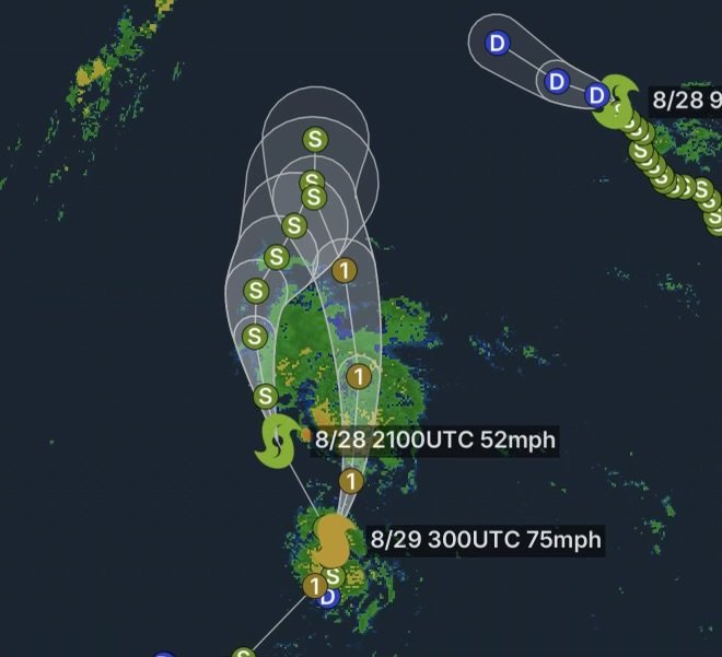
As of August 28, Bang-Lang was located near 19.5°N, 166.5°E, moving northeast at approximately 11 mph. Current tracking information places its maximum sustained winds around 75 mph, making it a Category 1-equivalent typhoon on the Saffir-Simpson scale.
The storm is positioned near Wake Island and remains over open Pacific waters. Current information indicates the system is moving away from the western Pacific tropics rather than immediately threatening a major populated landmass.
Why Bang-Lang Matters
Bang-Lang’s development demonstrates how quickly tropical systems can intensify when they encounter a favorable combination of warm ocean water, sufficient atmospheric moisture and relatively supportive upper-level winds.
The storm has strengthened considerably during the past couple of days, with satellite and tracking data showing a well-defined tropical cyclone structure.
Because tropical systems can change intensity and direction quickly, mariners and interests across the open Pacific should continue monitoring official forecasts.
Tropical Storm Etau Tracks Northward
Another system nearby is Tropical Storm Etau.
Etau developed from a tropical disturbance in the western Pacific and has been moving generally northward over open water. Current tracking information places the storm near 26.2°N, 166.0°E, with maximum sustained winds around 50 mph.
Unlike Bang-Lang, Etau remains below typhoon strength. However, the system is another reminder that the western Pacific remains busy as August comes to a close.
Etau and the Open Pacific
Etau’s location means the most immediate concern is for marine interests rather than widespread impacts to populated land areas.
The storm is generating rough seas, strong winds and dangerous conditions for vessels near and around its circulation. Significant wave heights in the broader area can become hazardous as tropical cyclones strengthen and interact with surrounding weather systems.
Three Storms, Three Different Stages
The current Pacific pattern provides an excellent example of the tropical cyclone life cycle:
| System | Current Status | Approx. Winds | Main Area of Concern |
| Lala | Post-Tropical Cyclone | 40 mph | Weakening over open Pacific |
| Bang-Lang | Category 1 Typhoon | 75 mph | Open Pacific near Wake Island |
| Etau | Tropical Storm | 50 mph | Open western Pacific |
These systems demonstrate that tropical weather threats do not all look the same. One storm can be dissipating while another rapidly intensifies nearby.
What to Watch Next
Forecasters will continue watching Bang-Lang and Etau for changes in strength, track and interaction with the broader atmospheric pattern.
At the same time, Lala’s remnants should gradually lose their identity as a tropical system. The National Hurricane Center’s final advisory indicated that Lala was expected to dissipate within approximately two days.
For anyone traveling across the Pacific, operating vessels, or monitoring tropical weather, official forecasts should remain the primary source for warnings and rapidly changing conditions.
Radar Watch HQ Final Thoughts
The Pacific remains active on August 28, with Post-Tropical Lala, Category 1 Typhoon Bang-Lang and Tropical Storm Etau showing three distinct phases of tropical cyclone development.
Lala is fading after a long journey across the Pacific and a significant period of impacts around Hawaii. Bang-Lang, meanwhile, has strengthened into a Category 1 typhoon, while Etau continues as a tropical storm over open water.
Even when storms are far from land, conditions can become dangerous for ships and aircraft operating nearby. Stay informed, monitor official tropical cyclone forecasts, and never rely on an older forecast when a storm is actively changing.
Stay weather-aware with Radar Watch HQ, and check back for continuing updates on tropical systems across the Pacific.