Washington Air Quality Alert and Red Flag Warning
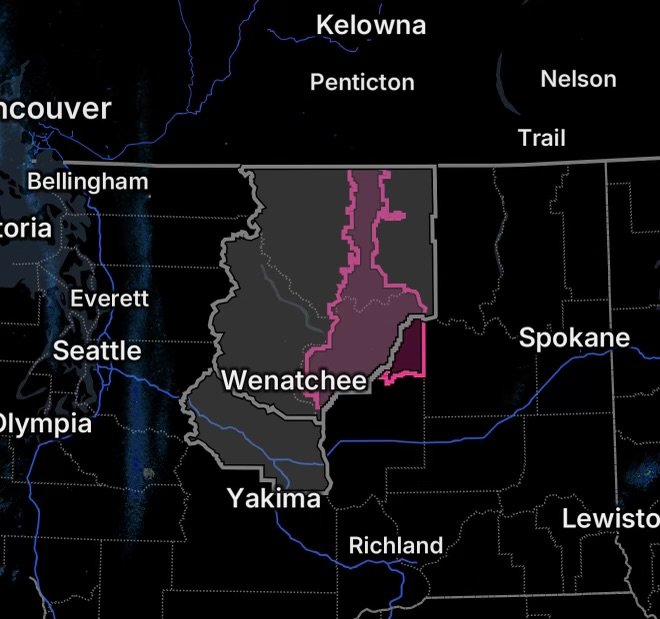
North-central Washington is facing a dangerous combination of smoke, dry air, low humidity, and gusty winds today, August 27, 2026. A Washington air quality alert remains in effect for Chelan County, Douglas County, and Okanogan County because of current and expected wildfire smoke. At the same time, a Red Flag Warning is in effect for the Okanogan Valley and Waterville Plateau, highlighting the potential for rapid wildfire growth. (National Weather Service)
These hazards can reinforce one another. Dry vegetation can ignite easily, while smoke from existing fires can significantly reduce air quality downwind.
Air Quality Alert: Chelan, Douglas and Okanogan Counties
The Washington Department of Ecology has issued an Air Quality Alert because regional wildfires are producing smoke that could affect communities across the three counties.
Fine particles known as PM2.5 may reach unhealthy levels, particularly in areas downwind of active fires. The National Weather Service advises residents to check local air monitors before spending extended periods outdoors. (National Weather Service)
Communities included in the alert area include:
- Wenatchee
- Leavenworth
- Cashmere
- Entiat
- Chelan
- Manson
- Plain
- East Wenatchee
- Bridgeport
- Waterville
- Omak
- Okanogan
- Tonasket
- Brewster
- Oroville
- Mazama
- Winthrop
- Methow
- Twisp
- Conconully (National Weather Service)
Who is most vulnerable?
Smoke can affect anyone, but people with respiratory or cardiovascular sensitivities, older adults, children, and people who spend significant time outdoors may be particularly vulnerable.
When air quality becomes unhealthy, residents should reduce exposure by limiting outdoor time and avoiding strenuous outdoor activity. Keeping indoor air cleaner can also reduce exposure.
Red Flag Warning: Okanogan Valley and Waterville Plateau
The fire-weather threat is especially serious across the Okanogan Valley and Waterville Plateau.
The Red Flag Warning is in effect from noon through 8 p.m. PDT today for Fire Weather Zones 703 and 706. Forecast conditions include southwest winds around 15 to 25 mph with gusts up to 35 mph, followed by a shift toward northwest winds. Relative humidity is expected to fall as low as 16% to 24%. (Weather Underground)
Why these conditions matter
Low humidity removes moisture from grasses, brush, and other vegetation. Meanwhile, gusty winds can quickly push flames across dry fuels.
As a result, any new fire could spread rapidly, while existing wildfires may become more difficult to control.
Wildfire Risk and Smoke Could Increase Quickly
The combination of a Red Flag Warning and an Air Quality Alert creates two separate but connected hazards.
Fire danger: Dry fuels, low humidity, and strong winds can support rapid wildfire growth.
Smoke danger: Existing fires can produce unhealthy concentrations of fine particulate matter, particularly when winds transport smoke into populated areas.
Therefore, residents should monitor both fire conditions and air quality, rather than focusing on only one hazard.
What Residents Should Do Today
Protect yourself from wildfire smoke
If smoke becomes heavy:
- Check your local air-quality readings before exercising outdoors.
- Reduce strenuous outdoor activity.
- Keep windows and doors closed when outdoor air quality is poor.
- Use appropriate indoor air filtration if available.
- Follow local health and emergency-management guidance.
Reduce wildfire ignition risks
During critical fire-weather conditions:
- Avoid activities that could create sparks.
- Do not burn debris or conduct outdoor burning.
- Properly extinguish cigarettes and other ignition sources.
- Follow local fire restrictions.
- Keep vehicles from parking on dry grass.
- Be prepared to leave quickly if evacuation orders are issued.
What to Watch Through Tonight
The most concerning period for fire behavior is during the Red Flag Warning this afternoon and evening, when winds and very low humidity combine to create conditions favorable for rapid fire spread. (Weather Underground)
Meanwhile, smoke conditions may vary considerably from one community to another depending on wind direction, fire activity, and terrain.
Residents should continue checking official air-quality information and local emergency notifications throughout the day.
Radar Watch HQ Safety Reminder
A Red Flag Warning does not mean a wildfire is already burning in every affected location. Instead, it means weather conditions are favorable for fires to start and spread rapidly.
If a fire develops nearby, conditions can deteriorate quickly. Have multiple ways to receive emergency alerts, know your evacuation routes, and be ready to leave if authorities issue an evacuation order.
Radar Watch HQ Final Thoughts
August 27 brings a significant smoke and wildfire-weather threat to north-central Washington. Chelan County, Douglas County, and Okanogan County remain under an Air Quality Alert because of wildfire smoke, while the Okanogan Valley and Waterville Plateau face critical fire-weather conditions under a Red Flag Warning. (National Weather Service)
The key message today is simple: limit smoke exposure, avoid creating sparks, monitor changing conditions, and take evacuation warnings seriously.
Stay weather-aware, stay fire-safe, and keep checking Radar Watch HQ for developing weather hazards.

Affiliate Disclosure: As an Amazon Associate, Radar Watch HQ earns from qualifying purchases.
Radar Watch HQ Top 5 Essential Emergency Preparedness Picks
Whether you’re preparing for severe thunderstorms, flash flooding, hurricanes, wildfires, or extended power outages, these five emergency essentials can help keep your household safer when severe weather strikes.
A portable power station provides reliable backup electricity during outages, allowing you to power phones, medical devices, laptops, lights, small appliances, and communication equipment without fuel.
Best for:
- Extended power outages
- Severe thunderstorms
- Hurricanes
- Winter storms
- Wildfires
2. Flood Protection Barriers & Sandless Flood Bags
Flood barriers help divert or absorb water before it enters garages, doorways, and low-lying areas. They deploy quickly and can help reduce property damage during flash flooding.
Best for:
- Flash Flood Warnings
- Heavy rainfall
- River flooding
- Coastal flooding
3. Rechargeable LED Flashlights
Bright, dependable flashlights are essential when the power goes out. Rechargeable or solar-powered models provide long-lasting illumination for navigating safely indoors and outdoors.
Best for:
- Overnight power outages
- Emergency evacuations
- Storm damage inspections
Keep phones, tablets, weather radios, and USB-powered devices charged when the electrical grid is unavailable. A solar power bank offers an additional charging option during prolonged emergencies.
Best for:
- Communication during outages
- Emergency weather alerts
- Travel and evacuation
A NOAA Weather Radio delivers official weather alerts directly from the National Weather Service, even when cellular networks or internet service are unavailable. It remains one of the most dependable ways to receive life-saving warnings.
Best for:
- Tornado warnings
- Severe thunderstorm warnings
- Flash flood warnings
- Hurricane alerts
- Winter storm emergencies
Why Radar Watch HQ Recommends These Essentials
At Radar Watch HQ, preparedness is just as important as staying informed. These five emergency essentials can help you stay connected, protect your property, and safely navigate severe weather events. Having supplies ready before storms arrive allows you to respond quickly when warnings are issued and conditions begin to deteriorate.