Red Flag Warning Creates Dangerous Fire Weather Across Southern California
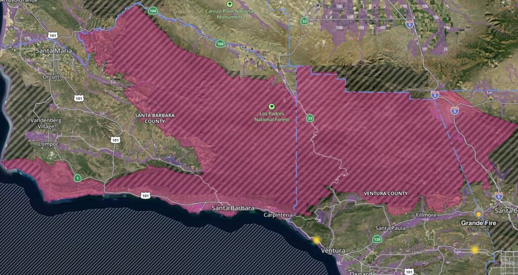
A Red Flag Warning has been issued for much of Santa Barbara County, Ventura County, the Santa Ynez Mountains, and the Interstate 5 Corridor, where a combination of strong northwest to north winds, hot temperatures, and critically low relative humidity is expected to create extremely dangerous wildfire conditions from late Wednesday through early Thursday.
Communities across the warning area should prepare for rapidly changing fire conditions, as any wildfire that develops could spread quickly under these weather conditions.
Areas Under the Red Flag Warning
The warning includes:
- Santa Barbara County Southwestern Coast
- Santa Barbara County Southeastern Coast
- Santa Barbara County Interior Mountains
- Santa Ynez Mountains Western Range
- Santa Ynez Mountains Eastern Range
- Northern Ventura County Mountains
- Southern Ventura County Mountains
- Interstate 5 Corridor
These regions are especially vulnerable due to dry vegetation, steep terrain, and seasonal offshore wind patterns that can accelerate wildfire growth.
Critical Fire Weather Ingredients
Meteorologists are closely monitoring a dangerous combination of atmospheric conditions, including:
- Strong northwest to north winds
- Hot daytime temperatures
- Relative humidity dropping into critically low levels
- Extremely dry fuels capable of igniting easily
- Poor overnight humidity recovery in elevated terrain
Even a small spark from equipment, vehicles, campfires, or power lines could quickly develop into a fast-moving wildfire.
Impact on Los Padres National Forest
The Los Padres National Forest faces an elevated wildfire threat during this Red Flag Warning.
Large portions of the forest have experienced prolonged drying throughout the summer, leaving grasses, shrubs, and chaparral highly receptive to ignition. Strong winds moving through mountain passes and canyons can rapidly push flames across rugged terrain, making wildfire suppression significantly more difficult.
Potential impacts include:
- Rapid fire spread through dense chaparral
- Increased spotting as embers are carried long distances by wind
- Difficult access for firefighters in mountainous terrain
- Temporary trail, campground, and road closures if fire activity develops
- Reduced visibility from smoke affecting nearby highways and communities
The combination of steep terrain and strong winds has historically contributed to several of Southern California’s largest wildfire events.
Why the Interstate 5 Corridor Is a Concern
The Interstate 5 Corridor frequently experiences accelerated winds as air funnels through mountain passes.
These stronger winds can:
- Increase wildfire spread rates
- Blow embers well ahead of the main fire
- Reduce visibility for motorists
- Increase the likelihood of roadside fire starts
Drivers should avoid parking vehicles over dry grass and ensure trailer chains are secured to prevent sparks.
Santa Barbara and Ventura Counties Face Elevated Risk
The mountainous areas of Santa Barbara and Ventura Counties contain extensive wildland vegetation that dries rapidly during periods of hot, windy weather.
Fire officials often increase staffing during Red Flag events because fires can:
- Double in size within minutes under strong winds
- Cross containment lines unexpectedly
- Threaten homes near the wildland-urban interface
- Require rapid evacuations if communities become threatened
Residents living near canyons, foothills, and forested areas should remain alert for changing conditions.
Fire Safety Recommendations
Residents and visitors should take extra precautions during the warning:
- Avoid outdoor burning.
- Never leave campfires unattended.
- Properly extinguish cigarettes.
- Delay activities that create sparks, including welding or grinding.
- Avoid parking vehicles on dry grass.
- Prepare emergency evacuation plans.
- Keep emergency kits readily available.
- Monitor local emergency alerts for evacuation information.
Weather Pattern Driving the Warning
This Red Flag Warning is being driven by a strong pressure gradient producing gusty northwest to north winds behind a passing weather system. While temperatures remain hot, sinking air behind the system is also lowering humidity values to critical levels.
This combination creates one of Southern California’s most dangerous wildfire weather patterns, particularly across mountain ranges and coastal valleys where wind speeds can become locally enhanced.
Although some areas may see cooler temperatures later in the week, elevated fire danger will remain until stronger winds weaken and humidity levels recover.
Radar Watch HQ Weather Outlook
Residents across Santa Barbara County, Ventura County, the Santa Ynez Mountains, the Interstate 5 Corridor, and those recreating in Los Padres National Forest should remain vigilant through early Thursday.
Any wildfire ignition during this period has the potential to spread rapidly under strong winds and critically dry conditions. Continue monitoring local emergency officials and weather updates, and be prepared to act quickly if evacuation orders or warnings are issued.
Affiliate Disclosure: As an Amazon Associate, Radar Watch HQ earns from qualifying purchases.
Radar Watch HQ Top 5 Essentials – Wildfire Preparedness
Helps reduce exposure to wildfire smoke, ash, and fine particles.
Provides alerts during power outages or when cell service is unavailable.
Go Bag / Emergency Preparedness Kit
Includes important documents, medications, water, food, flashlights, and basic supplies for quick evacuation.
Fire-Resistant Outdoor Supplies
Items such as fire-resistant gloves, protective clothing, and tools for creating defensible space around property.
Portable Power Bank & Backup Charging Supplies
Keeps phones and emergency devices powered during wildfire emergencies.