Nevada Faces a Complex Weather Threat on August 12
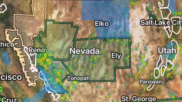
Several weather concerns are developing across Nevada and nearby eastern California on Wednesday, August 12, 2026, with flooding potential, power outages and active fire-weather concerns occurring across portions of the region.
A broad area of moisture is supporting thunderstorms capable of producing heavy rainfall, strong outflow winds, lightning and localized flash flooding. The National Weather Service office in Reno says thunderstorms with heavy rain, hail and strong outflow winds are expected to expand northward today and Thursday, increasing both the flash-flood threat and the potential for new lightning-caused fires. (National Weather Service)
At the same time, reported power outages in Elko County, Nevada, and Mono County, California, add another concern for residents dealing with potentially hazardous weather.
Flood Watch Expands Across Parts of Nevada
A Flood Watch is highlighting portions of eastern, north-central, south-central and west-central Nevada as moisture and thunderstorms increase.
Eastern Nevada
The Flood Watch includes White Pine County and surrounding areas of eastern Nevada.
Residents should remain alert for rapidly developing thunderstorms, heavy downpours and runoff that could overwhelm normally dry washes, drainage areas and low-lying roads.
Southern Lander and Southern Eureka Counties
In north-central Nevada, the Flood Watch includes Southern Lander County and Southern Eureka County.
Thunderstorms can produce rainfall rates that overwhelm drainage systems quickly. Even locations that do not receive the heaviest rainfall directly can experience runoff flowing downstream from higher terrain.
Northeastern and Northwestern Nye Counties
The Flood Watch also includes portions of south-central Nevada, including:
- Northeastern Nye County
- Northwestern Nye County
These areas should watch for storms capable of producing heavy rainfall, frequent lightning and sudden runoff.
West-Central Nevada Flood Threat
A Flood Watch is also in effect for portions of west-central Nevada, including the Western Nevada Basin and Range and the Pyramid Lake area.
Thunderstorms developing over the mountains can move into valleys and drainage basins, creating a risk of sudden water rises and localized flooding.
Drivers should never attempt to cross a flooded roadway. Water depth and current strength can be difficult to judge, and road conditions can deteriorate rapidly during intense thunderstorms.
Eastern California and Western Nevada Also Included
The flood threat extends into eastern California and western Nevada.
The highlighted area includes Mono County, California, along with Mineral County and Southern Lyon County, Nevada.
This region is particularly important to monitor because thunderstorms can bring multiple hazards at the same time, including:
- Heavy rainfall
- Flash flooding
- Frequent lightning
- Strong and erratic winds
- Small hail
- Rapid changes in visibility
- New wildfire ignitions from lightning
The National Weather Service Reno forecast discussion specifically warns that the expanding thunderstorm activity will increase the threat of flash flooding and new lightning fires. (National Weather Service)
Elko County Power Outage Reported
A power outage is being reported in Elko County, adding another layer of concern as thunderstorms and strong winds affect parts of Nevada.
Severe or strong thunderstorms can damage power infrastructure through lightning, gusty winds, falling branches and other storm-related impacts.
Residents experiencing an outage should:
- Keep flashlights and battery-powered devices available.
- Avoid downed or damaged power lines.
- Keep refrigerators and freezers closed as much as possible.
- Unplug sensitive electronics if conditions allow.
- Monitor local utility information for restoration updates.
- Use generators only outdoors and well away from windows, doors and vents.
If you see a downed power line, stay away and report it to the appropriate utility or emergency authorities.
Mono County Power Outage Concern
A power outage is also being reported in Mono County, California, where thunderstorms and changing weather conditions are adding to the operational challenges across the region.
Residents should be prepared for the possibility that additional storms could cause temporary outages or disrupt travel and communications.
People who rely on electrically powered medical equipment or other essential devices should have an emergency backup plan and monitor local emergency information.
Active Fire Weather Alerts Add Another Layer of Risk
Flooding is not the only concern.
Active fire-weather alerts across portions of Nevada and eastern California mean thunderstorms could create a dangerous combination of lightning, gusty winds and dry fuels.
This creates a particularly challenging situation: rainfall may reduce fire danger in areas receiving substantial precipitation, while nearby areas can experience lightning with little meaningful rainfall.
The National Weather Service has warned that thunderstorms may produce strong outflow winds and lightning capable of starting new fires. (National Weather Service)
Earlier fire-weather guidance for Nevada has also emphasized the combination of dry fuels and critical fire conditions across portions of northern and central Nevada. (National Weather Service)
Why Lightning Is a Concern
A lightning strike can ignite vegetation even when rain is falling nearby. Strong thunderstorm outflow winds can then spread flames rapidly across dry grass, brush and other fuels.
Residents should avoid activities that could create sparks and follow all local fire restrictions.
Flooding and Fire Can Happen at the Same Time
One of the most important messages for Nevada residents today is that flooding and wildfire threats are not mutually exclusive.
A thunderstorm can produce heavy rainfall in one location while generating lightning and strong winds in another.
Burn scars and areas with recently disturbed vegetation can be especially vulnerable to rapid runoff, erosion and debris flows during intense rainfall.
Travel Conditions Could Change Quickly
Drivers traveling across Nevada and eastern California should be prepared for rapidly changing conditions.
Heavy rain can sharply reduce visibility, while water may accumulate on roads and low-water crossings. Strong thunderstorm outflows can also create sudden crosswinds, blowing dust and hazardous driving conditions.
If a severe storm approaches, avoid unnecessary travel and move to a safe location.
What Residents Should Do Now
With multiple hazards occurring across the region, residents should take a few minutes to prepare:
- Check the latest weather alerts before traveling.
- Charge phones and backup batteries.
- Keep flashlights available in case of additional outages.
- Avoid flooded roads and washes.
- Stay away from downed power lines.
- Take lightning seriously, especially when outdoors.
- Follow local fire restrictions.
- Monitor evacuation information if a wildfire develops nearby.
- Secure loose outdoor objects before strong winds arrive.
- Have multiple ways to receive emergency alerts.
Radar Watch HQ Weather Alert
The combination of Flood Watches, reported power outages and active fire-weather concerns makes August 12, 2026, an important day to remain weather aware across Nevada and eastern California.
Thunderstorms can develop and intensify quickly, and conditions may vary significantly from one community to another. Residents should continue monitoring official weather alerts and local emergency information throughout the day.
Stay alert. Stay prepared. Stay safe.
Follow Radar Watch HQ
For continued coverage of severe weather, flooding, fire weather, power outages and developing hazards across the United States, follow Radar Watch HQ for the latest weather updates.
When weather conditions change, be ready to act.

Affiliate Disclosure: As an Amazon Associate, Radar Watch HQ earns from qualifying purchases.
Radar Watch HQ Top 5 Essential Emergency Preparedness Picks
Whether you’re preparing for severe thunderstorms, flash flooding, hurricanes, wildfires, or extended power outages, these five emergency essentials can help keep your household safer when severe weather strikes.
A portable power station provides reliable backup electricity during outages, allowing you to power phones, medical devices, laptops, lights, small appliances, and communication equipment without fuel.
Best for:
- Extended power outages
- Severe thunderstorms
- Hurricanes
- Winter storms
- Wildfires
2. Flood Protection Barriers & Sandless Flood Bags
Flood barriers help divert or absorb water before it enters garages, doorways, and low-lying areas. They deploy quickly and can help reduce property damage during flash flooding.
Best for:
- Flash Flood Warnings
- Heavy rainfall
- River flooding
- Coastal flooding
3. Rechargeable LED Flashlights
Bright, dependable flashlights are essential when the power goes out. Rechargeable or solar-powered models provide long-lasting illumination for navigating safely indoors and outdoors.
Best for:
- Overnight power outages
- Emergency evacuations
- Storm damage inspections
Keep phones, tablets, weather radios, and USB-powered devices charged when the electrical grid is unavailable. A solar power bank offers an additional charging option during prolonged emergencies.
Best for:
- Communication during outages
- Emergency weather alerts
- Travel and evacuation
A NOAA Weather Radio delivers official weather alerts directly from the National Weather Service, even when cellular networks or internet service are unavailable. It remains one of the most dependable ways to receive life-saving warnings.
Best for:
- Tornado warnings
- Severe thunderstorm warnings
- Flash flood warnings
- Hurricane alerts
- Winter storm emergencies
Why Radar Watch HQ Recommends These Essentials
At Radar Watch HQ, preparedness is just as important as staying informed. These five emergency essentials can help you stay connected, protect your property, and safely navigate severe weather events. Having supplies ready before storms arrive allows you to respond quickly when warnings are issued and conditions begin to deteriorate.